Understanding flood risk is a priority for the City of Dawson Creek. Floods come in all sizes, and they result in different impacts. Flooding is the City's highest ranked hazard. To reduce flood risk and vulnerabilities, the City has adopted mitigation strategies and projects.
Understanding flood risk
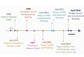
Over the last decade, the City has experienced seven floods. The 2016 flood was the largest in recent history. After this event, the City updated their flood maps to understand flood depth and flood impacts for different sized events. The City has applied flood mitigation strategies to reduce impacts and increase resiliency.
Flood mitigation
Mitigation strategies reduce the impact of flooding on residents and property. There are two types of mitigation:
Structural mitigation
Engineered structures are used to control flood risk. The City approaches structural mitigation with the “build back better” mentality. Below are some of the projects completed to reduce impacts during flood events:
- Bridges at four main crossings will reduce upstream water levels and backwatering
- 108th lift station to assist in diverting water during intense rain events
- Sewer trunk line was installed in 2012 to redirect sanitary flows
Non-structural mitigation
The City has adopted non-structural programs to support flood mitigation and preparedness efforts. This includes:
- Annual insurance information sharing
- Flushing program for sanitary sewer lines
- No-mow policy in riparian areas
- On-going emergency training and exercises for staff and community volunteers
- Updating the Storm Water Master Plan and Sanitary Sewer Master Plan
Bylaws and regulatory maps
In 2021, Council adopted the updated floodplain and riparian hazard bylaws and Flood mapping to align with current legislative requirements. These maps are based off the Flood Mapping Project. The adopted maps include the Floodplain Map, the Riparian Hazard Map, and the Flood Construction Level Map. View map layers on the City's Interactive Webmap.